ポスターについて
販売:
このデザインについて
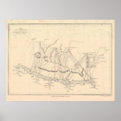
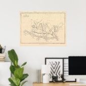
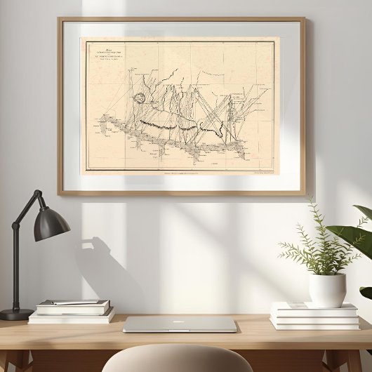
1858 Col. Waugh Everest & Deodanga Map Poster ポスター
A restored fine-art edition of Colonel Andrew Scott Waugh’s 1858 survey map — the first chart to define Mount Everest, where science, legend, and exploration converged.
Rediscover a landmark in exploration with this meticulous restoration of Colonel Andrew Scott Waugh’s 1858 Map of Mount Everest and Deodanga — the chart that first fixed the world’s highest mountain in recorded geography.
Originally published by the Royal Geographical Society, this historic map accompanied Waugh’s paper defending the name “Everest” against “Deodanga”, then locally used for the same distant Himalayan peak.
Every triangulation line, river, and survey station has been faithfully vector-restored, from the Purniah Base through Simraha and Phulchowki to the great Himalayan arc joining Chomolhari, Kangchenjunga, and Everest itself.
This fine-art edition honors the quiet precision of 19th-century cartography while bringing it to life with modern clarity — a timeless collectible for lovers of maps, mountains, and exploration history.
Based on the original engraving by Col. Andrew Scott Waugh, R.G.S., London, 1858.

カスタマーレビュー
5つ星評価のうち星4.8全レビュー数 40
レビュー:40
類似商品のレビュー
5つ星評価のうち星5
k.2024年3月11日 • 認証済みのご注文
ポスター、サイズ: 40.64cm x 30.48cm, ハードウェア: なし, フレーム: なし, メディア: バリューポスター用紙(セミグロス), マット: なし,
とても綺麗に仕上がりました。思ったように印刷されています。 パソコンデータとほとんど変わりなくカラーも再現されて細部も綺麗に印刷されていました。
5つ星評価のうち星5
k.2024年3月11日 • 認証済みのご注文
ポスター、サイズ: 40.64cm x 30.48cm, ハードウェア: なし, フレーム: なし, メディア: バリューポスター用紙(セミグロス), マット: なし,
とても綺麗に印刷されていました。用意した額に入れて飾っています。 カラーについても鮮やかに印刷されていてよかったです。ありがとうございました。
5つ星評価のうち星5
k.2024年3月11日 • 認証済みのご注文
ポスター、サイズ: 40.64cm x 30.48cm, ハードウェア: なし, フレーム: なし, メディア: バリューポスター用紙(セミグロス), マット: なし,
鮮やかなカラーも再現されていてとてもよく仕上がっていました。
用意した額に飾っています。 カラーも綺麗に再現されプリントも綺麗でした。満足の仕上がりです。
タグ
その他の情報
商品 ID: 256443529385812756
出品日: 2025/10/16 9:01
レーティング: G
最近閲覧された商品