ポスターについて
販売:
このデザインについて
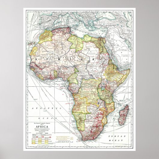
" Africa: 1909 - Detailed map ... ポスター
This beautiful historical map of Africa by National Geographic shows the continent as it looked in 1909. At that time, the "Dark Continent" was barely known in the outside world. Here you will find the country borders of the independent states and the Congo state as well as areas under the control of Egypt, England, Germany, Spain, Italy, Turkey, France and Portugal. In addition, the steamship lines, cable and telegraph lines and railway lines - including the planned - are marked. Using the ocean liners, you can see which routes from other parts of the world have taken you to African destinations. Gold, silver and diamond fields can also be seen on this historic map.
Store

カスタマーレビュー
5つ星評価のうち星4.7全レビュー数 41
レビュー:41
類似商品のレビュー
5つ星評価のうち星5.0
5つ星評価のうち星5 k.2024年3月11日 • 認証済みのご注文
ポスター、サイズ: 40.64cm x 30.48cm, ハードウェア: なし, フレーム: なし, メディア: スタンダード(セミグロス), マット: なし,
とても綺麗に仕上がりました。思ったように印刷されています。 パソコンデータとほとんど変わりなくカラーも再現されて細部も綺麗に印刷されていました。
5つ星評価のうち星5.0
5つ星評価のうち星5 k.2024年3月11日 • 認証済みのご注文
ポスター、サイズ: 40.64cm x 30.48cm, ハードウェア: なし, フレーム: なし, メディア: スタンダード(セミグロス), マット: なし,
とても綺麗に印刷されていました。用意した額に入れて飾っています。 カラーについても鮮やかに印刷されていてよかったです。ありがとうございました。
5つ星評価のうち星5.0
5つ星評価のうち星5 k.2024年3月11日 • 認証済みのご注文
ポスター、サイズ: 40.64cm x 30.48cm, ハードウェア: なし, フレーム: なし, メディア: スタンダード(セミグロス), マット: なし,
鮮やかなカラーも再現されていてとてもよく仕上がっていました。
用意した額に飾っています。 カラーも綺麗に再現されプリントも綺麗でした。満足の仕上がりです。
タグ
その他の情報
商品 ID: 228625324185418077
出品日: 2020/10/8 1:01
レーティング: G